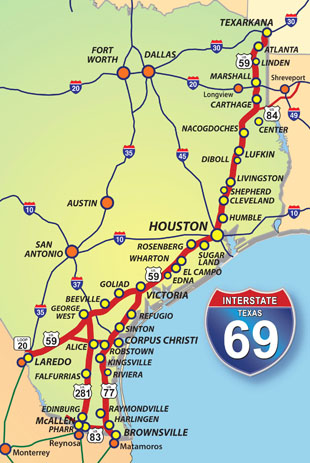
• I-69 Texas Resource Materials
Gulf Intracoastal Waterway Report to the 2025 Texas Legislature. PDF (13 MB)
Corpus Christi I-69 Update Presentation, Januarty 2020. The slide presentation was presented to a regional transportation forum by Charlie Zahn, chairman of the Port of Corpus Christi Commission and a member of the Alliance Board. PDF (2.3 MB)
Rio Grande Valley I-69 Connectivity Update Presentation, December 2019. This PowerPoint was created by Cameron County Commissioner David A. Garza, a member of the Alliance for I-69 Texas board of directors. - PPT (5.7 MB)
Transportation Commission Briefing on Rural Connectivty, December 2019. This annual update is a preliminary to funding decisions that will be part of the 2021 UTP. PDF (4.5 MB)
Momentum Continues to Build Update / Benefits of Alliance Membership brochure, December 2019, an overview of goals and opportunities for 2020. December 2019. PDF (2 MB)
Alliance Annual Luncheon Program, Nov. 25, 2019.
2019 INTERSTATE 69 DC FLY-IN: The following are DOWNLOADABLE Files from the September 2019 DC Fly-in involving all states on the I-69 national route:
I-69 Multi-State Slide Presentation (23 MB)
Multi-State Update Folder ( Prints 11x17)
Multi-State Update (Prints Letter)
National Freight Network Map (2 MB)
Texas Freight Network Maps (3.5 MB)
1960-1990 Interstate Maps (0.6 MB)
Texas DC Handout 2019 (1.3 MB)
I-69 Texas Project Status by Congressional District (6.6 MB)
-----------
TxDOT Overview of 2019 State Legislative Actions, June 2019. - PDF (2 MB)
I-69 Day in Austin 2019 Follow-Up Report, February 4, 2019. This document includes photos from the Alliance presentation to the Transportation Commission and a review of events including the honoring of Commissioner Jeff Austin for his support of I-69. PDF
I-69 Day in Austin 2019 brochure, January 30, 2019. This sheet was used by members of the I-69 delegation making visits to the individual offices of members of the Legislature. - PDF (1.6 MB)
----------
TxDOT Funding Program for Interstate 69, April 2015. This is the latest version of the map tracking funding for projects since the funding program was started in 2010. - PDF (2.4 MB)
TxDOT I-69 System Planning and Environmental Status, August 2015. This is the latest version of the map tracking environmental studies and potential relief route planning efforts along the 1,000 miles of I-69 route in Texas. - PDF (2.6 MB)
I-69 Washington Fly-In 2015. Representatives of 8 states along the I-69 national route participated in a "DC Fly-In" to urge support for passage of a federal highway bill with adequate funding for projects like I-69. DOWNLOADS of multi-state materials from these sessions are here:
2. I-69 Multi-State Status Report Folder 4.22.15 - PDF (1.2 MB)
3. National Status Map 4.1.15 - PDF (810 KB)
4. I-69 Freight Flow Map 5.8.13 - PDF (186 KB)
DOWNLOADS of Texas materials from the DC Fly-In are here:
1. I-69 Texas Status Report 4.17.14 - PDF (992 KB)
2. Status of Texas Projects by Congressional District 4.22.15 - (2.7 MB)
3. I-69 Funding Program Status With Detail 4.1.15 - (2.6 MB)
4. Current I-69 Texas Environmental and Planning 4.1.15 - (3.6 MB)
5. Map of Currently Designated Sections of I-69 4.1.15 - (1.7 MB)
I-69 Texas Status Update Briefing, January 14, 2015. Community leaders, lawmakers and legislative staff from along the I-69 route in Texas were invited to participate in a briefing in conjunction with the annual Texas Transportation Forum. The briefing included remarks by Loyd Neal, Alliance Board Chairman; Transportation Commissioner Jeff Austin III; and Judy Hawley, chair of TxDOT's I-69 Advisory Committee. DOWNLOADS of meeting materials:
1. I-69 Alliance Introductory Presentation 1.14.15 - PowerPoint file (3.4 MB)
2. I-69 Interstate Designation Status Map (Nov. '14) - PDF (2.2 MB)
3. I-69 Planning and Environmental Status Map (Nov. '14) - PDF (1.6 MB)
4. Map of I-69 System Funding Program since 2010 (Nov. '14) - PDF (714 K)
5. I-69 National System Status Map (July ' 14) - PDF (232 K)
I-69 Alliance Legislative Program & Board Members, February 2015. The Alliance for I-69 Texas supports passage of new, long-term, sustainable funding sources for transportation. The Board of Directors adopted a program for the 2015 session of the Texas Legislature.
I-69 Congressional Caucus Letter, January 31, 2014. This letter signed by members of the Caucus was sent to Secretary of Transportation Anthony Foxx in support of including I-69 as a designated part of the Nationla Freight Network being identified under a provision of MAP-21.
TxDOT Freight Transportation Planning, January 6, 2014. This TxDOT presentation was made at the Alliance board meeting in San Antonio by Caroline Mays, a member of the department's Freight Planning Branch staff.
US 281/US 59 Upgrade Planning and Feasibility Study, October 2013. This feasiblity study includes a program of projects to upgrade US 281 and US 59 to I-69 interstate standards in the 155 miles from I-2 the McAllen area to I-37 east of George West in South Texas.
I-69 Project Update by TxDOT, November 18, 2013. This presentation was delivered to the Alliance Board of Directors by Marc Williams, P.E., TxDOT Director of Planning.
Alliance Washington, D.C. Update. This series of PDF files makes up the update materials used by Alliance for I-69 Texas representatives during their May 2013 visit with lawmakers and federal agencies in the nation's capital. DOWNLOADS:
1. I-69 Progress Report for Spring 2013 (1.7 MB)
2. I-69 National Route Map (2.2 MB)
3. I-69 Freight Connectivity Map (187 K)
4. TxDOT I-69 Funding Program (1.8 MB)
5. Status of Pending Designations to Add to I-69 in Texas (5.9 MB)
Click HERE for JPG copies of these files.
Map Showing Funded I-69 Projects as of April 1, 2013. This map is prepared by TxDOT and updated periodically to reflect I-69 route projects that have been funded or have been marked for funding. Some of the projects are now complete, some will be in construction soon and others are still several years away from starting.
I-69 Route Redesignation Map, March 1, 2013. This TxDOT map shows the progress being made on winning federal authority to add sections of existing freeways to the Interstate Highway System as I-69.
Final Report of the I-69 Advisory Committee, Dec. 13, 2012. This report brings together the recommendations of the five citizen segment committees and the statewide committee.
I-69 Progress Report for 2012, Dec. 10, 2012. This is a 2-page summary of progress in 2012 and of the 2013 objectives of the Alliance for I-69 Texas.
Alliance Update Presentation for 2012, Nov. 27, 2012. This slide presentation provides a summary of Alliance activity and successes during 2012. It was presented by Alliance Chairman John Thompson to a gathering in Nacogdoches.
Map Showing Funded I-69 Projects, Oct. 29, 2012. This map is prepared by TxDOT and updated periodically to reflect major upgrade projects on the I-69 Texas routes that have been funded in the past few years. Some are under construction and some are programmed over the coming years.
Maps Showing Recommendations of I-69 Segment Committees, June 20, 2011. These maps show the recommendations and priorities for upgrade projects on the routes that make up the I-69 corridor. More than 100 volunteers appointed by local governments and organizations served on the committees for more than two years.
I-69 Update to Transportation Commission, November 18, 2010. These are the Powerpoint slides used by John Barton, TxDOT Assistant Executive Director, in providing the Commission with a update on I-69 development and the work of the five Segment Committees.
A Citizens's Report on the Current and Future Needs of the I-69 Corridor. This is the 2008 report of the I-69 Advisory Committee appointed by the Texas Transportation Commission. The report set the stage for creation of the locally-driven planning process taken on by five Segment Committees starting in 2009.
US 77 Upgrade Project Public Meeting Presentation. This presentation was utilized during four public meetings in March 2008 for the schematic design and environmental assessment process covering US 77 from I-37 to Harlingen. The process was in the final stages of review in mid 2011.
.